This site uses cookies. By continuing to browse the site you are agreeing to our use of cookies. Read our privacy policy.
Area of Outstanding Natural Beauty
-
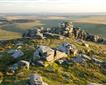
Bodmin Moor
The granite uplands of the Bodmin Moor AONB section are exposed and sometimes desolate; it's a treeless landscape of heath, bare rock, peat bogs and mires.
-
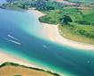
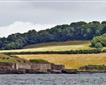
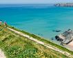
Camel Estuary
The Camel Estuary AONB is a broad tidal river valley, over half a mile wide at Padstow. It stretches lazily inland for five miles up to Wadebridge.
-
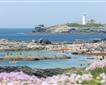
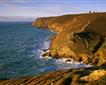
Godrevy to Portreath
High cliffs, rocky shores and small coves form this beautiful AONB coastline.
-
Hartlands
The AONB Section from Morwenstow to Kilkhampton has superb coastal scenery, with coastal heathland meeting granite cliffs.
-
Pentire Point to Widemouth
The AONB from Pentire Point to Widemouth encompasses an unspoilt rocky coast, including the highest cliffs in Cornwall.
-
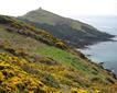
Rame Head
Rame Head AONB is formed of a rocky shoreline punctuated by popular sandy beaches.
-
South Coast Central
This AONB Section embraces the The Fal Ria; including Mylor, Feock and the Roseland Coast to Porthpean.
-
South Coast Eastern
The AONB from Par Sands to Looe encompasses the Fowey ria. This drowned river valley forms a network of creeks that lead toward a coastline of low cliffs and small beaches.
-
South Coast Western
This AONB Section stretches from Lizard to Marazion, encompassing the Helford River.
-
St Agnes - AONB
This AONB Section encompasses the rocky coast from Porthtowan to Cligga Head, and includes St. Agnes Beacon. The St. Agnes mining district is a Cornish Mining World Heritage Site
-
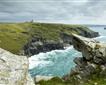
Trevose Head to Stepper Point
This AONB Section has an extremely varied coastal scenery, from the high headlands of Trevose Head and Stepper Point to the large cliffs and rocky stacks of the Bedruthan Steps.
-

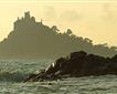
West Penwith
West Penwith AONB is a sparsely populated peninsula, ringed by high cliffs and rising to high, rocky moorland at its centre.